Câmara de Lobos · Inland, the centre of the island
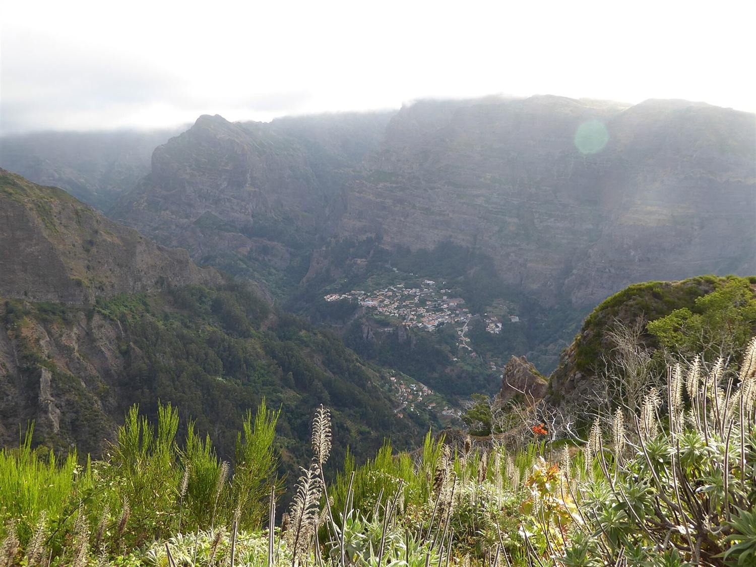
Curral das Freiras: one road in, and walls on every side
The short answer
Curral das Freiras is a single village on the floor of a near-enclosed volcanic bowl in the centre of Madeira, reached by one tunnelled road. It has a weekday health centre with no urgência, no chain supermarket, no school registered in the parish, and one bus route. Chestnuts are the local crop.
Ground elevation at the centre of Curral das Freiras
659 m
Copernicus DEM sample at the centre point.
Copernicus DEM GLO-90 via the Open-Meteo elevation API · check it · read August 26, 2026Highest ground sampled within about 700 m of the centre
1,186 m
The sample describes terrain near the centre point, not the full parish, which runs higher still.
Copernicus DEM GLO-90 via the Open-Meteo elevation API · check it · read August 26, 2026Curral das Freiras parish, area
25.07 km²
As the municipality states it.
Câmara Municipal de Câmara de Lobos · check it · read August 26, 2026Curral das Freiras parish, resident population
1,580
Censos 2021, Quadro 10. The municipality’s own page gives 1,585; this site uses the census table.
DREM / INE, 2021 · check it · read August 26, 2026Usual base of Madeira’s trade-wind cloud layer
600–800 m
Descends lower in summer. This is the band that produces fog drip.
Governo Regional da Madeira (portal da geodiversidade) · check it · read August 26, 2026Usual top of Madeira’s trade-wind cloud layer in winter
about 1,600 m
Villages above roughly 500–600 m are materially cloudier and cooler than the coast below them.
Governo Regional da Madeira (portal da geodiversidade) · check it · read August 26, 20265 more sourced figures on this page
Mean annual air temperature, Monte station, 2025
16.6 °C
A proxy at similar altitude, not a measurement of this valley. 17.7 °C in 2024.
DREM — Direção Regional de Estatística da Madeira · check it · read August 26, 2026Mean wind speed, Monte station, 2024
4.8 km/h
Predominant direction N. Sheltered rather than exposed.
DREM — Direção Regional de Estatística da Madeira · check it · read August 26, 2026Eira do Serrado viewpoint, height
1,095 m
Medium confidence: the figure comes from Visit Madeira and appears on no municipal page.
Visit Madeira · check it · read August 26, 2026Curral das Freiras to Funchal, modelled
23 minutes
OSRM free-flow output over 15.5 km. Not a measured journey, and there is no alternative road.
OSRM over OpenStreetMap data · check it · read August 26, 2026Curral das Freiras to Madeira Airport, modelled
35 minutes
OSRM free-flow output over 31.3 km, to the departures forecourt on Avenida das Partidas. Not a measured journey.
OSRM over OpenStreetMap data · check it · read August 28, 2026Curral das Freiras is the most dramatic address on Madeira and one of the least practical. It sits on the floor of a bowl in the middle of the island, the walls climb past a thousand metres within a kilometre of the village, and one tunnelled road connects it to everything else.
The municipality’s own description is blunt: hemmed in among very high mountains, and historically isolated by that position.
The shape of the ground is the whole story
The elevation model puts the centre of the village at 659 m, source: Copernicus DEM GLO-90 via the Open-Meteo elevation API, read August 26, 2026, with terrain within a few hundred metres of that point rising to 1,186 m, source: Copernicus DEM GLO-90 via the Open-Meteo elevation API, read August 26, 2026. That range describes ground near the centre, not the parish, which covers 25.07 km², source: Câmara Municipal de Câmara de Lobos, read August 26, 2026 and runs a great deal higher again.
Two consequences follow, and neither appears in a photograph. The valley sits in or just under the trade-wind cloud band, which normally forms between 600–800 m, source: Governo Regional da Madeira (portal da geodiversidade), read August 26, 2026 and about about 1,600 m, source: Governo Regional da Madeira (portal da geodiversidade), read August 26, 2026 in winter and drops lower in summer. And the surrounding peaks cut direct winter sunshine short at both ends of the day, regardless of what the forecast for the coast says.
What is not here
Centro de Saúde do Curral das Freiras, on Estrada Cónego Camacho, opens on weekdays only. There is no urgência. The nearest twenty-four-hour urgent care is down in Câmara de Lobos, and the region’s only twenty-four-hour hospital emergency department is in Funchal.
Neither national supermarket chain lists a store in the parish, and Lidl has none anywhere in the archipelago. No school is registered here in the regional school registry either: the nearest listed establishment, Escola Básica com Pré-escolar de Santo António, has its registered address in Funchal. One bus route serves the village, running from the cable-car terminus down to the church and Lombo Chão. Every Madeiran route number changed to three digits on 9 March 2026.
What is here
The municipality states that the parish works almost exclusively in agriculture, with chestnuts and sour cherries as the principal crops. The Festa da Castanha was first held here on 1 November 1983 and was, per the municipality, the first festival in Portugal to honour the chestnut.
Above the village, the Eira do Serrado viewpoint sits at 1,095 m, source: Visit Madeira, read August 26, 2026 and gives an unobstructed view over the whole parish. That height comes from Visit Madeira rather than from any municipal page, so it is recorded at medium confidence.
The drive, and who has left
Modelled at free-flow speed over OpenStreetMap data, Funchal is 23 minutes, source: OSRM over OpenStreetMap data, read August 26, 2026 and the airport 35 minutes, source: OSRM over OpenStreetMap data, read August 28, 2026. Those look short, and on a clear day they are. They are also routing-engine outputs with no weather, no roadworks and no traffic, on a road that has no alternative.
The parish counted 1,580, source: DREM / INE, 2021, read August 26, 2026 residents at the 2021 census, and DREM singled out Curral das Freiras and Jardim da Serra as the two parishes with the largest population losses in Câmara de Lobos municipality across the census decade. The nearest weather station with a published series is Monte, which recorded 16.6 °C, source: DREM — Direção Regional de Estatística da Madeira, read August 26, 2026 mean annual air temperature in 2025 and mean wind of 4.8 km/h, source: DREM — Direção Regional de Estatística da Madeira, read August 26, 2026 in 2024 — a proxy at similar altitude, not a measurement of this valley.
Who it does not suit
Almost every practical purpose except seclusion — the valley walls cut the winter sun short at both ends of the day, there is no coast, no chain supermarket and no school in the parish, and DREM named it one of the two parishes losing population fastest in its municipality.
Questions people actually ask
Is there a shop in Curral das Freiras?
Neither national supermarket chain lists a store in the parish, and Lidl has none anywhere in the archipelago. That is an absence from two locators, not proof that nothing exists — Madeira has many unbranded minimercados no national locator carries. A household here should plan a weekly shop as a drive out of the valley.
Is there a school in Curral das Freiras?
None is registered in the regional government’s school registry for the parish. The nearest listed establishment, Escola Básica com Pré-escolar de Santo António, has its registered address in Santo António, Funchal. For a family, that makes the school run a daily trip through the tunnel in each direction.
How much sunlight does the valley actually get?
Less than the coast, and the reason is geometry rather than weather. The village floor sits at 659 m, source: Copernicus DEM GLO-90 via the Open-Meteo elevation API, read August 26, 2026 with ground within a few hundred metres rising to 1,186 m, source: Copernicus DEM GLO-90 via the Open-Meteo elevation API, read August 26, 2026, so the surrounding walls cut direct winter sun short at both ends of the day. The valley also sits in or just under the cloud band that normally forms between 600–800 m, source: Governo Regional da Madeira (portal da geodiversidade), read August 26, 2026 and about about 1,600 m, source: Governo Regional da Madeira (portal da geodiversidade), read August 26, 2026.
How long does it take to get to Funchal?
The modelled drive is 23 minutes, source: OSRM over OpenStreetMap data, read August 26, 2026 — a routing engine at free-flow speed with no traffic, no roadworks and no weather. One tunnelled road serves the village, and it has no alternative, so anything that closes it closes the valley. The airport is a modelled 35 minutes, source: OSRM over OpenStreetMap data, read August 28, 2026.
Where this came from
- SESARAM: Diretório de serviços — centros de saúde. sesaram.pt/portal/utente/diretorio-de-servicos/centr Read August 26, 2026.
- Governo Regional da Madeira: Dados dos estabelecimentos de ensino, 2024/2025. place.madeira.gov.pt/place21/nStyles/Bootstrap/img/assets/Dado Read August 26, 2026.
- SIGA, Governo Regional da Madeira: Renumeração das carreiras para três dígitos, em vigor desde 09/03/2026. siga.madeira.gov.pt/noticias/show/2069 Read August 26, 2026.
- Pingo Doce: Store locator API (national store list). pingodoce.pt/wp-content/themes/pingodoce/ajax/pd-ajax. Read August 26, 2026.
- Governo Regional da Madeira (portal da geodiversidade): Prada et al., Disponibilidades Hídricas da Ilha da Madeira. geodiversidade.madeira.gov.pt/images/documentos/Publicacoes/Madeira/Dis Read August 26, 2026.
- Câmara Municipal de Câmara de Lobos: Freguesia do Curral das Freiras. cm-camaradelobos.pt/informacoes/concelho/freguesias/freguesia Read August 26, 2026.
- Câmara Municipal de Câmara de Lobos: Agenda — Festa da Castanha, Curral das Freiras. agenda.cm-camaradelobos.pt/menu/lista-de-eventos/evento/1166-festa-d Read August 26, 2026.
- Visit Madeira: Eira do Serrado viewpoint. visitmadeira.com/en/where-to-go/madeira/south-coast/camara Read August 26, 2026.
- Copernicus DEM GLO-90 via the Open-Meteo elevation API: Ground elevation at the centre point and four points about 700 m away. api.open-meteo.com/v1/elevation Read August 26, 2026.
- DREM / INE: Censos 2021, resultados definitivos — Quadro 10, resident population by geographic location. estatistica.madeira.gov.pt/en/download-now-3/social-gb/popcondsoc-gb Read August 26, 2026.
- DREM — Direção Regional de Estatística da Madeira: Temperatura do ar anual, 2000–2025 (série retrospetiva, dados meteorológicos). estatistica.madeira.gov.pt/download-now/ambiente-territorio/dados-me Read August 26, 2026.
- DREM — Direção Regional de Estatística da Madeira: Velocidade e rumo do vento, 2012–2025 (série retrospetiva, dados meteorológicos). estatistica.madeira.gov.pt/download-now/ambiente-territorio/dados-me Read August 26, 2026.
- OSRM over OpenStreetMap data: Free-flow driving route — modelled output, not a measured journey. router.project-osrm.org/route/v1/driving/-16.9657129,32.720835;-1 Read August 26, 2026.
- OSRM over OpenStreetMap data: Free-flow driving route — modelled output, not a measured journey. router.project-osrm.org/route/v1/driving/-16.9657129,32.720835;-1 Read August 28, 2026.