Câmara de Lobos · South coast
Estreito de Câmara de Lobos: vineyard ground, twelve minutes from the city
The short answer
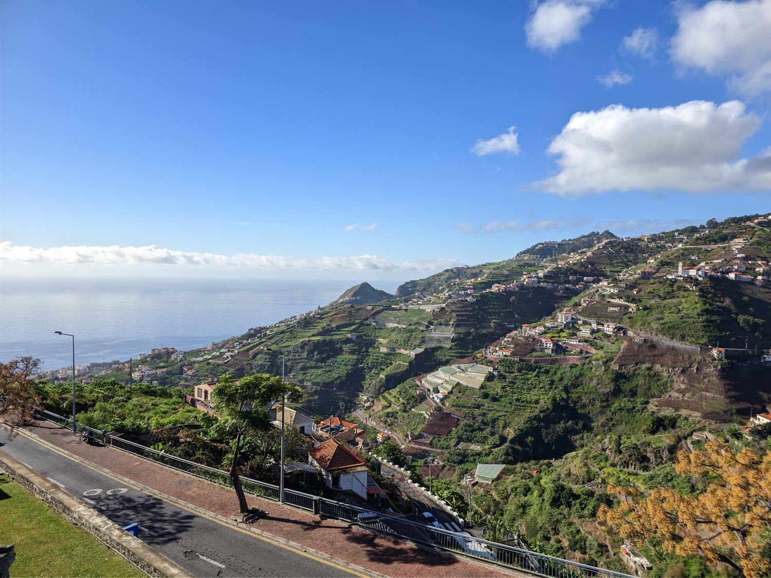
Estreito de Câmara de Lobos is a terraced village on the slope above the coast town of the same municipality, high enough to run several degrees cooler than the seafront. It has a supermarket, three state schools and a weekday health centre with no urgência, and the modelled drive into Funchal is short.
Estreito de Câmara de Lobos parish, resident population
9,348
Censos 2021, Quadro 10. No parish estimate exists after the census.
DREM / INE, 2021 · check it · read August 26, 2026Ground elevation at the centre of the village
468 m
Copernicus DEM sample at the centre point.
Copernicus DEM GLO-90 via the Open-Meteo elevation API · check it · read August 26, 2026Lowest ground sampled within about 700 m of the centre
346 m
Terrain near the centre point, not the parish, which runs to the coast.
Copernicus DEM GLO-90 via the Open-Meteo elevation API · check it · read August 26, 2026Highest ground sampled within about 700 m of the centre
535 m
Terrain near the centre point only.
Copernicus DEM GLO-90 via the Open-Meteo elevation API · check it · read August 26, 2026Usual base of Madeira’s trade-wind cloud layer
600–800 m
Descends lower in summer.
Governo Regional da Madeira (portal da geodiversidade) · check it · read August 26, 2026Usual top of that cloud layer in winter
about 1,600 m
Villages above roughly 500–600 m are materially cloudier than the coast below them.
Governo Regional da Madeira (portal da geodiversidade) · check it · read August 26, 20266 more sourced figures on this page
Mean annual air temperature, Quinta Grande, 2025
17.6 °C
A station at similar altitude nearby. 18.5 °C in 2024.
DREM — Direção Regional de Estatística da Madeira · check it · read August 26, 2026Mean annual air temperature, Funchal/Observatório, 2025
20.8 °C
Sea level, same year, for comparison.
DREM — Direção Regional de Estatística da Madeira · check it · read August 26, 2026Annual rainfall, Quinta Grande, 2025
711.5 mm
498.6 mm in 2024.
DREM — Direção Regional de Estatística da Madeira · check it · read August 26, 2026Estreito to Funchal, modelled
12 minutes
OSRM free-flow output over 10.4 km. Not a measured journey.
OSRM over OpenStreetMap data · check it · read August 26, 2026Estreito to Madeira Airport, modelled
25 minutes
OSRM free-flow output over 26.8 km, to the departures forecourt on Avenida das Partidas. Not a measured journey.
OSRM over OpenStreetMap data · check it · read August 28, 2026Health centres with an urgência, out of all SESARAM health centres
9 of 47
Câmara de Lobos, down the hill, is one of them. Estreito is not.
SESARAM · check it · read August 26, 2026Estreito de Câmara de Lobos is the village above the harbour, and the difference between the two is roughly four hundred and fifty metres of hill. That buys terraces, vines, quiet and a view, and it costs the sea.
It is also one of the most populous parishes in its municipality, with the services that implies, and a short run into the capital.
What is actually in the village
Centro de Saúde do Estreito de Câmara de Lobos, on Rua João Augusto Ornelas, opens on weekdays. It has no urgência — but the twenty-four-hour urgent-care service at Câmara de Lobos, down the hill, is one of 9 of 47, source: SESARAM, read August 26, 2026 SESARAM health centres that has one. The region’s only twenty-four-hour hospital emergency department remains in Funchal.
There is a Continente Modelo on Rua das Vinhas. Lidl has no store anywhere in the archipelago. Schooling is unusually complete for a village: two state primaries with pre-school plus the Escola Básica 2/3 do Estreito de Câmara de Lobos.
Buses run direct to Funchal and to Castelejo, with five more local routes. All Madeiran route numbers changed to a three-digit scheme on 9 March 2026, and some old numbers now belong to different routes entirely, so any earlier list is stale.
High enough to be cooler, low enough to stay clear
The elevation model puts the village centre at 468 m, source: Copernicus DEM GLO-90 via the Open-Meteo elevation API, read August 26, 2026, with ground within a few hundred metres running between 346 m, source: Copernicus DEM GLO-90 via the Open-Meteo elevation API, read August 26, 2026 and 535 m, source: Copernicus DEM GLO-90 via the Open-Meteo elevation API, read August 26, 2026. That describes terrain near the centre point rather than the parish, which continues down towards the coast.
At that height the village sits below the usual cloud base — the trade-wind layer normally forms between 600–800 m, source: Governo Regional da Madeira (portal da geodiversidade), read August 26, 2026 and about about 1,600 m, source: Governo Regional da Madeira (portal da geodiversidade), read August 26, 2026 in winter — but high enough to be measurably cooler than the seafront. The Quinta Grande station, at similar altitude nearby, averaged 17.6 °C, source: DREM — Direção Regional de Estatística da Madeira, read August 26, 2026 in 2025 against 20.8 °C, source: DREM — Direção Regional de Estatística da Madeira, read August 26, 2026 at Funchal/Observatório, with 711.5 mm, source: DREM — Direção Regional de Estatística da Madeira, read August 26, 2026 of rain.
Who lives here, and the drive
Estreito de Câmara de Lobos counted 9,348, source: DREM / INE, 2021, read August 26, 2026 residents at the 2021 census, which makes it one of the larger parishes in the municipality. DREM publishes no parish-level estimates after the census, so the figure is four years old.
Modelled at free-flow speed over OpenStreetMap data, Funchal is 12 minutes, source: OSRM over OpenStreetMap data, read August 26, 2026 and the airport 25 minutes, source: OSRM over OpenStreetMap data, read August 28, 2026. The Funchal figure is among the shortest on this site for anywhere outside the capital, and it is the main practical argument for living up here rather than on the coast below.
Who it does not suit
Sea-swimmers — there is no beach access from the village, and anything coastal means a drive down and a climb back up at the end of it.
Questions people actually ask
Is Estreito de Câmara de Lobos cooler than the coast?
Measurably. The Quinta Grande station, at similar altitude nearby, averaged 17.6 °C, source: DREM — Direção Regional de Estatística da Madeira, read August 26, 2026 across 2025 against 20.8 °C, source: DREM — Direção Regional de Estatística da Madeira, read August 26, 2026 at Funchal/Observatório at sea level. The village centre sits at 468 m, source: Copernicus DEM GLO-90 via the Open-Meteo elevation API, read August 26, 2026, below the usual cloud base of 600–800 m, source: Governo Regional da Madeira (portal da geodiversidade), read August 26, 2026, so it is cooler without being routinely in cloud.
Is there a beach at Estreito de Câmara de Lobos?
No. The village is several hundred metres up the slope and has no coastal frontage of its own. Anything at sea level means a drive down to Câmara de Lobos and a climb back afterwards, which is a small thing on a viewing day and a larger one as a daily habit.
What schools are in the village?
Two state primaries with pre-school and the Escola Básica 2/3 do Estreito de Câmara de Lobos, so schooling to lower secondary without leaving the parish. Neither of the archipelago’s international schools is here — both are in Funchal, a modelled 12 minutes, source: OSRM over OpenStreetMap data, read August 26, 2026 away.
Does the village have urgent care?
No. Its centro de saúde opens on weekdays only. The twenty-four-hour urgent-care service at Câmara de Lobos, down the hill, is one of 9 of 47, source: SESARAM, read August 26, 2026 SESARAM health centres with an urgência at all. The only twenty-four-hour hospital emergency department in the region is at Hospital Dr. Nélio Mendonça in Funchal.
Where this came from
- SESARAM: Diretório de serviços — centros de saúde. sesaram.pt/portal/utente/diretorio-de-servicos/centr Read August 26, 2026.
- SESARAM: Urgência — horário dos serviços. sesaram.pt/portal/utente/urgencia/horario-dos-servic Read August 26, 2026.
- Governo Regional da Madeira: Dados dos estabelecimentos de ensino, 2024/2025. place.madeira.gov.pt/place21/nStyles/Bootstrap/img/assets/Dado Read August 26, 2026.
- SIGA, Governo Regional da Madeira: Renumeração das carreiras para três dígitos, em vigor desde 09/03/2026. siga.madeira.gov.pt/noticias/show/2069 Read August 26, 2026.
- Continente: Lojas — Madeira. feed.continente.pt/lojas/madeira Read August 26, 2026.
- Governo Regional da Madeira (portal da geodiversidade): Prada et al., Disponibilidades Hídricas da Ilha da Madeira. geodiversidade.madeira.gov.pt/images/documentos/Publicacoes/Madeira/Dis Read August 26, 2026.
- Câmara Municipal de Câmara de Lobos: Caraterização e localização do concelho. cm-camaradelobos.pt/informacoes/concelho/caraterizacao-e-loca Read August 26, 2026.
- DREM / INE: Censos 2021, resultados definitivos — Quadro 10, resident population by geographic location. estatistica.madeira.gov.pt/en/download-now-3/social-gb/popcondsoc-gb Read August 26, 2026.
- Copernicus DEM GLO-90 via the Open-Meteo elevation API: Ground elevation at the centre point and four points about 700 m away. api.open-meteo.com/v1/elevation Read August 26, 2026.
- DREM — Direção Regional de Estatística da Madeira: Temperatura do ar anual, 2000–2025 (série retrospetiva, dados meteorológicos). estatistica.madeira.gov.pt/download-now/ambiente-territorio/dados-me Read August 26, 2026.
- DREM — Direção Regional de Estatística da Madeira: Precipitação anual, 2000–2025 (série retrospetiva, dados meteorológicos). estatistica.madeira.gov.pt/download-now/ambiente-territorio/dados-me Read August 26, 2026.
- OSRM over OpenStreetMap data: Free-flow driving route — modelled output, not a measured journey. router.project-osrm.org/route/v1/driving/-16.9799729,32.6710994;- Read August 26, 2026.
- OSRM over OpenStreetMap data: Free-flow driving route — modelled output, not a measured journey. router.project-osrm.org/route/v1/driving/-16.9799729,32.6710994;- Read August 28, 2026.